Muscatine Art Center
Muscatine, IA
319-263-8282
Minnesota from the Mississippi
 In "Minnesota from the Mississippi;"
19th Century paintings, prints and drawings from the Art Center's permanent
collection are on view through September 23, 2001. Starting with early maps
viewers will travel the Mississippi from Itasca Lake (the source of the
River) to Winona. These thirty-seven historic views provide visitors with
an understanding of the River as an early source of inspiration for artists
as well as an important source of trade, commerce and westward expansion.
Also included are four important Currier & Ives prints depicting the
story of Hiawatha, the epic poem written by Longfellow in 1855.
In "Minnesota from the Mississippi;"
19th Century paintings, prints and drawings from the Art Center's permanent
collection are on view through September 23, 2001. Starting with early maps
viewers will travel the Mississippi from Itasca Lake (the source of the
River) to Winona. These thirty-seven historic views provide visitors with
an understanding of the River as an early source of inspiration for artists
as well as an important source of trade, commerce and westward expansion.
Also included are four important Currier & Ives prints depicting the
story of Hiawatha, the epic poem written by Longfellow in 1855.
Text from gallery labels as seen in the exhibition:
1. THE VALLEY OF THE UPPER MISSISSIPPI., Charles Graham/Harper's
Weekly, October 6, 1883, lithograph with hand coloring, Gift of Mr. &
Mrs. John Stevens.
2. MAP Exhibiting ROUTES BY WHICH THE NAVIGATION of the
MISSISSIPPI RIVER MAY BE CONNECTED WITH THE NAVIGATION of the LAKES., Captain
T. J. Cram, 1846, lithograph with hand coloring.
3. A MAP OF A PORTION OF THE INDIAN COUNTRY LYING EAST
AND WEST OF THE MISSISSIPPI RIVER TO THE FORTY SIXTH DEGREE OF NORTH LATITUDE
FROM PERSONAL OBSERVATION MADE IN THE AUTUMN OF 1835 AND RECENT AUTHENTIC
DOCUMENTS., G.W.F., 1835, lithograph, Gift of Mrs. Jerome C. (Marianna)
Bishop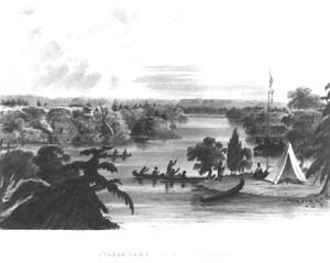
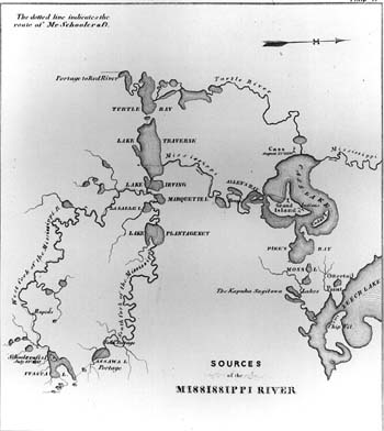
4. ITASCA LAKE (SOURCE OF THE MISSISSIPPI RIVER), after
a drawing by Captain Seth Eastman, engraver: John T. Bowen, 1851, lithograph
with original hand coloring, source: Historical and Statistical Information
Respecting the History, Condition and Prospects of the Indian Tribes of
the United States, Vol. I by Henry R. Schoolcraft.
5. Die kleinen Wasserfalle., translation: The Little
Falls (also known as Minnehaha Falls), Henry Lewis, engraver: Arnz &
Co., drawing done 1846-49, chromolithograph with some hand coloring, source:
published 1854-57 in Das Illustrirte Mississippithal.
Henry Lewis was born in England in 1819. At the age of
10 he emigrated to America with his father and brothers. After a few years
in Boston, Lewis settled in St. Louis, Missouri, in 1836, where he was employed
as a scene painter. From 1846 to 1848 he traveled up and down the Mississippi
making sketches which he later developed into a panorama executed in Cincinnati,
Ohio between 1848 and 1849. After exhibiting the panel in several mid-western
and eastern cities in America, Lewis took it to Europe in 1850. He exhibited
the panorama in Holland, England and Germany, and in 1853, settled in Dusseldorf.
There, in 1854, Lewis published Das Illustrirte Mississippithal,
with a descriptive text and 78 plates after his own sketches. From 1867
to 1884, Lewis served as a United States consular agent in Dusseldorf, and
continued to paint until his death in 1904.
* "Minnehaha Falls, together with the Falls of St.
Anthony, were two "musts" for any vacationer making what George
Catlin appropriately called in his North American Indians "The Fashionable
Tour." Henry Lewis was no exception; he quickly visited Minnehaha Falls
and made a painting of this beauty spot which has always attracted thousands
of visitors."
According to Henry Lewis:
- From the Falls of St. Anthony an enormous prairie reaches
out in all directions. Toward the north and the west it disappears on the
distant horizon; toward the southwest it touches upon the St. Peter's [Minnesota]
River and stretches for another eight miles over the bottom lands formed
by the junction of the same with the Mississippi and is bordered by the
hills of the St. Peter's Valley; toward the south it reaches as far as
Fort Snelling which is built on the high promontory overlooking the confluence
of the two rivers.
-
- There is in this region much of interest for the naturalist,
as well as for the admirer of the scenic beauty especially among the thrilling
waterfalls; one of these, about two and one-half miles distant from Fort
Snelling, is called 'Brown's Fall'-'Little Fall'-or also 'Calhoun's Fall'-and
is of all of them by far the most interesting.
A fuller historical description of Minnehaha Falls was
written by Warren Upham in his Minnesota Geographic Names, appearing
as Volume 17 in the Collections of the Minnesota Historical Society.
According to Upham:
- Minnehaha Falls received the name of Brown's Falls on
the Fort map of 1823, in honor of Jacob Brown, major general and commander
in chief of the army from 1814 until his death, February 24, 1828; but
Minnehaha creek on that map, quite erroneous in its course, bears no name...
-
- The name Minnehaha is cited by Longfellow's "Song
of Hiawatha," published in 1855, as used by Mrs. Mary H. Eastman in
the introduction of her book, "Dakotah, or Life and Legends of the
Sioux around Fort Snelling," published in 1849. She there wrote: "The
scenery about Fort Snelling is rich in beauty. The Falls of St. Anthony
are familiar to travelers, and to readers of Indian sketches. Between the
fort and these falls are the 'Little Falls,' 40 feet in height, on a stream
that empties into the Mississippi. The Indians call them Mine-hah-hah,
of 'laughing waters.'"
-
- The common Sioux word for waterfall is "haha,"
which they applied to the falls of St. Anthony, to Minnehaha, and in general
to any waterfall or cascade. To join the words "minne," water,
and "haha," a fall, seems to be a suggestion of white men, which
thereafter came into use among the Indians...
6. MINNEHAHA OR BROWN'S FALLS NEAR FORT SNELLING, delineator:
John Mix Stanley, engraver: Sarony, Major & Knapp Lithographers, 1860,
duotone lithograph with later hand coloring, source: Stevens Report of the
47th Parallels, Vol. XII Book I
7. MIN-NE-HA-HA-FALLS., engraver: John Gemmell, c.1870,
lithograph with hand coloring
8. FALLS OF ST. ANTHONY ON THE MISSISSIPPI. (with separate
text), Joshua Shaw, engraver: John Hill, published 1860 by M. Carey &
Son in Picturesque Views of American Scenery, Gift of Dr. & Mrs.
Laurence D. Gatzke
* "The Falls of St. Anthony were named by Father Louis
Hennepin (of Aco-Hennepin fame) in honor of his patron saint in 1680. In
1837 George Catlin, the colorful American Indian artist, helped popularize
the Falls when he urged his fellow-Americans to make the "Fashionable
Tour" to the Upper Mississippi. By 1848, when artist Henry Lewis visited
the spot, the falls had become a magnet for European as well as American
tourists. Steamboat captains frequently advertised excursions in newspapers
under the catching title-"Ho! for the Falls of St. Anthony!" The
Falls became the prime objective of the "Grand Excursion of 1854"
sponsored by the Rock Island railroad to celebrate the completion of the
first railroad to link the Atlantic with the Mississippi opposite Davenport.
Artist Henry Lewis declared Timothy Flint had written the
best description of the Mississippi River. Flint's description of the Falls
of St. Anthony, as quoted by Lewis, follows with mileage corrected by the
present author-editor.
According to Henry Lewis:
- Eleven hundred miles [512] below its source, and seven
hundred and seventy-one [670] above St. Louis, are the Fall of St. Anthony.
Here the river is about six hundred yards wide, and is precipitated over
a ledge of limestone seventeen feet high. The scenery around the falls
is grand and imposing and affords a fine treat to tourists, many of whom
travel here every year, to witness this sublime and beautiful spot.
9. FALLS OF ST. ANTHONY., after a watercolor by Captain
Seth Eastman, engraver: Christian Schuessele, publisher: Peter S. Duval,
1853, chromolithograph, source: Romance of Indian Life by Mary Eastman.
10. FALLS OF THE MISSISSIPPI, artist unknown, undated,
wood engraving, source: Ladies Repository. Gift of E. Bradford Burns.
11. FALLS OF ST. ANTHONY, delineator: Captain Seth Eastman,
engraver: J. C. McRae, c.1851-57, steel engraving, source: Historical
Information Respecting the Indian Tribes of North America by Henry Schoolcraft,
Gift of E. Bradford Burns
12. THE FALLS AND TOWN OF ST. ANTHONY, ON THE UPPER MISSISSIPPI,
OVER TWO THOUSAND MILES FROM THE GULF OF MEXICO, AT THE HEAD OF NAVIGATION
ON "THE GREAT FATHER OF WATERS"., Edwin Whitefield, wood engraving
with hand coloring, source: Frank Leslie's Illustrated Newspaper,
May 9, 1857, Gift of E. Bradford Burns.
13. VIEW OF THE FALLS OF ST. ANTHONY, ON THE UPPER MISSISSIPPI,
TERRITORY OF MINNESOTA., Edwin Whitefield, lithograph, source: Frank
Leslie's Illustrated Newspaper, May 9, 1857, Gift of E. Bradford Burns.
14. Untitled (The Packet Boat: Edward J. Gay on the Mississippi),
Edwin Whitefield, correspondence letter with watercolor, c.1856, artist's
note: "View on the Mississippi No. 7-distant view of St. Anthony. This
view is taken from a point about 2 miles north of St. Anthony of which place
it shows a portion in the distance. About midway is a small but beautiful
island which adds very much to the loveliness of the scenery. There are
two or three very fine building spots right here, but the land cannot be
bought for less than $100 per acre. The country around is rolling, and the
soil is pretty good. Groves of scrub oak abound."
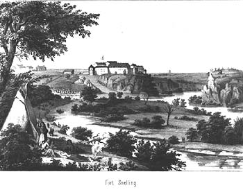 15. Fort Snelling., Henry Lewis,
engraver: Arnz & Co., drawings done 1846-49, chromolithograph with some
original hand coloring, source: published 1854-57 in Das Illustrirte
Mississippithal, Gift of Mr. & Mrs. James H. Kent.
15. Fort Snelling., Henry Lewis,
engraver: Arnz & Co., drawings done 1846-49, chromolithograph with some
original hand coloring, source: published 1854-57 in Das Illustrirte
Mississippithal, Gift of Mr. & Mrs. James H. Kent.
* "The site of Fort Snelling, at the junction of the
Minnesota and Mississippi rivers, was purchased from the Sioux Indians by
Zebulon M. Pike in 1805. Known from its founding in 1819 by various names
(including Camp Coldwater and Fort St. Anthony), General Winfield Scott
recommended in 1824 that the post be renamed for Colonel Josiah Snelling
'as a just compliment to the meritorious officer under whom it has been
erected.'
The scene of several Indian treaties, Fort Snelling has
been the training ground for many Iowa and other Midwestern soldiers in
peace and war. It saw the longest service of any fort in the Upper Mississippi
Valley, being in use from 1819 to 1946.
The comments of Henry Lewis on Fort Snelling are of particular
interest to Iowans, because of his inclusion of the Winnebago Indian lodges
in his picture, just after they had been removed from the Hawkeye State
to Minnesota in 1848."
According to Henry Lewis:
- Fort Snelling is located on the rocky point at the confluence
of the Mississippi with the St. Peter's [Minnesota River]. This bluff consists
of three different formations: the first of limestone filled with organic
remains, a second of sandstone, and the third of limestone without organic
remains.
-
- Looking to the right of the Fort, we behold a continuation
of the valley of the Mississippi, whilst to the left begins that of the
St. Peter's. At our feet, directly in front, to the east, lies a small
island, shaped like a triangle.
-
- This Island was originally covered with timber but it
is now nearly cleared so as to afford no cover to any enemy approaching
the fort. At the foot of the island the two streams [Mississippi and Minnesota]
fully unite and are seen flowing onward in one bed at the foot of towering
heights on one side, and forest and prairie, alternating with bluff, on
the other.
-
- The one presented on this illustration representing the
whole plain under the Fort covered with the lodges of the Winnebagoes,
who had thus far unwillingly advanced towards their new homes, but not
without a demonstration of compulsion on the part of the United States
troops, was picturesque and novel in the extreme; at the same time two
bands of Sioux Indians being encamped on the opposite bank of the St. Peter's
16. FORT SNELLING, MINNESOTA/CITY OF MUSCATINE, IOWA.,
Kilburn/W. Mull, engraver: Asa Coolidge Warren, wood cut with later hand
coloring, source: Ballou's Pictorial Drawing Room Companion, April
4, 1855.
17. Fort Snelling Junction of the Mississippi and Minnesota
Rivers, John S. Conway, oil on canvas, November 1874.
18. VIEW OF MINNEAPOLIS, MINN.FROM THE EAST OF THE MISSISSIPPI
. NICOLLET ISLAND IN THE FOREGROUND., from photographs by Jacoby, wood cut
engraving with hand coloring, 1878, source: The Daily Graphic.
19. SAINT PAUL., delineator: John Mix Stanley, engraver:
Sarony, Major & Knapp, duotone lithograph, 1860, source: Stevens Report
of the 47th and 49th Parellels, Vol. XII, Part 1, Gift of Virgil Norberg
* "The county seat of Ramsey County and the capital
of Minnesota, St. Paul was first settled by Pierre Parrant in 1838. It received
its name from a little Catholic chapel built under the direction of Father
Lucian Galtier in 1841. A French missionary, Father Galtier was ordained
a priest at Dubuque in 1840, settled for a time at Mendota, Minnesota, but
removed to Keokuk in 1844. Four years later he revisited France, only to
return to America where he took up residence in Prairie du Chien until his
death in 1866. The first Minnesota newspaper, the Minnesota Pioneer,
was printed at St. Paul in 1849, on the same press that printed Iowa' first
paper-the Du Buque Visitor in 1836. It was not organized as a village
or town until November 1, 1849."
According to Henry Lewis:
- This town is beautifully situated on the bluffs on the
eastern shore and was formerly the most northern settlement of white men
on the Mississippi. It is some four or five miles below Fort Snelling,
and there is a good road leading from this place to the Fort and the Falls
of St. Anthony.
20. ST. PAUL, FROM DAYTON'S BLUFF., Alfred R. Waud, engraver:
N. Orr & Co., wood engraving with later hand coloring, 1874, source:
Picturesque America, by William Cullen Bryant. 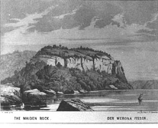
21. THE MAIDEN ROCK. DER WERONA FELSEN., Henry Lewis, engraver:
Arnz & Co., chromolithograph with some original hand coloring, source:
published 1854-57 in Das Illustrirte Mississippithal.
* "America is said to be sprinkled with romantic bluffs
from which lovesick and despondent Indian maidens are said to have thrown
their bodies in despair. One of the best known is maiden Rock on the Wisconsin
side of the Mississippi near the head of lake Pepin. It was from this bluff,
according to legend, that the Indian maiden Winona plunged to her death
in preference to being married, as her parents insisted, to a brave whom
she did not love. Passengers aboard steamboats were always thrilled by the
unhappy story of Winona and picturesque Maiden Rock."
22. MAIDEN ROCK. MISSISSIPPI RIVER., lithographer: Currier
& Ives, c.1871, lithograph with original hand coloring. 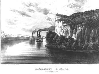
23. MAIDEN ROCK. MISSISSIPPI RIVER., lithographer: Currier
& Ives, c.1871, lithograph with original hand coloring, Purchased in
memory of Dr. John Klein.
24. WENONA'S LEAP. LAKE PEPIN, MISS. RIVER., after a watercolor
by Captain Seth Eastman, delineator: Christian Schuessele, publisher: Peter
S. Duval, 1852, chromolithograph, source: The Iris Souvenir and Illustrated
for 1852.
25. LAKE PEPIN MISS. RIVER, from a painting by A.T. Bricher,
engraver: R. Hinshelwood, 1872, steel engraving, source: Ladies Repository,
Gift of E. Bradford Burns.
26. View of the Upper Mississippi, Joachim Ferdinand Richardt,
1865, oil on canvas.
27. LACROSSE, AND SCENERY ABOVE: Steamboat landing, Lacrosse.
Scenery above Lacrofoe., Alfred R. Waud, 1874 wood engraving, source: Picturesque
America.
28. The Confluence, John Page, 1980, oil on canvas, Gift
of E. Bradford Burns.
* "The mouth of the Wisconsin River was of strategic
importance for two centuries following the discovery of Iowa by Joliet and
Marquette on June 17, 1673. Down this historic highway came Nicholas Perrot
to establish Fort St. Nicholas on the present site of Prairie du Chien in
1685. Along this waterway paddled the intrepid fur-traders to exchange blankets,
cloth, stroudings, guns, powder and scores of other items of use in the
trade for rich cargoes of furs and pelts. Jonathan Carver followed the Wisconsin
on his way to the Upper Mississippi in 1766 and Peter Pond, another Connecticut
Yankee, followed in his wake seven years later. Closely linked with Fort
Crawford at Prairie du Chien were two military posts-Fort Winnebago at Portage,
Wisconsin, and Fort Howard at Green Bay. Indian tribes, soldiers of the
frontier, and pioneers, both native-born and foreign, were aware of the
importance of the Wisconsin as a highway of commerce."
29. HIAWATHA'S WOOING, Louis Maurer, delineator: Hoomer,
engraver: Currier Ives, 1860, lithograph with original hand coloring, Gift
of Mrs. John L. (Beatrice) Klein.
- The noble American epic of Longfellow, in which he pictured
Hiawatha, "skilled in all the crafts of hunters," and...
- "the Arrow-maker's daughter,
- Minnehaha, Laughing Water,
- Handsomest of all the women,"
- so well appealed to the imagination of both the United
States and Great Britain, indeed of all where English is spoken, that soon
after its publication, in 1855, this name became known around the world,
the most widely honored and loved name in Minnesota history and legends.
30. HIAWATHA'S WEDDING, Maurer, lithographer: Currier &
Ives, 1858, lithograph with hand coloring, Gift of Mrs. John L. (Beatrice)
Klein.
31. Upper Mississippi River, Henry Lewis, 1855,
oil on canvas, Anonymous gift.
32. HIAWATHA'S DEPARTURE, lithographer: Currier & Ives,
1868, lithograph with original hand coloring. Gift of Mrs. John L. (Beatrice)
Klein.
33. THE DEATH OF MINNEHAHA, lithographer: Currier &
Ives, delineator: J. Cameron, 1867, chromolithograph with hand coloring,
Gift of Mrs. John L. (Beatrice) Klein.
34. RIVERS of AMERICA-THE MISSISSIPPI, Wm. Mark Young,
undated, lithograph, chromolithograph, Gift of E. Bradford Burns.
35. The Soaking Mountain on the Upper Mississippi,
J.C. Ward, engraver: Henry Jordan, 1836, steel engraving with hand coloring,
source: The New York Mirror, Gift of E. Bradford Burns.
36. LIMESTONE BLUFFS ON THE MISSISSIPPI, R.P. Mallory,
1870, pencil & pastel on brown paper, Gift of Muscatine County Museum
and Fine Arts Association.
37. SCENERY OF THE UPPER MISSISSIPPI. AN INDIAN VILLAGE,
lithographer: Currier & Ives, c.1866, lithograph with original hand
coloring, Gift of Dr. and Mrs. Laurence Gatzke.
*Reference: Mississippi River Panorama by William
J. Peterson
Read more about the Muscatine
Art Center in Resource Library Magazine
For further biographical information on selected artists
cited above please see America's Distinguished
Artists, a national registry of historic artists.
This page was originally published in Resource
Library Magazine. Please see Resource Library's Overview section for
more information. rev. 6/2/11
Search Resource
Library for thousands of articles and essays on American art.
Copyright 2011 Traditional Fine Arts Organization, Inc., an Arizona nonprofit corporation. All rights
reserved.