Editor's note: The Amon Carter Museum provided
source material to Resource Library Magazine for the following
article. If you have questions or comments regarding the source material,
please contact the Amon Carter Museum directly through either this phone
number or web address:
The Artist and the American
West: The Great Basin
Held June 15 - October
6, 2002, the exhibition from the Amon Carter Museum's permanent collection
The Artist and the American West: The Great Basin, chronicled the visual
history of the Great Basin, a high desert region of some 220,000 square
miles that includes portions of California, Idaho, Oregon, Nevada and Utah.
The name was first used by the explorer John C. Fremont in 1843-44. The
exhibition featured a number of notable images, from the earliest views
by explorer artists to provocative and stunning prints by contemporary photographers.
Following is wall panel text from the exhibition The
Artist and the American West: The Great Basin:
- The Great Basin includes almost all of Nevada, half of Utah west of
the Wasatch Mountains, parts of southern Oregon and Idaho, the southwestern
corner of Wyoming, the eastern side of the Sierras, and the Mohave of southern
California into the Baja. Geographically it is a large area of approximately
220,000 square miles, running roughly 900 miles north to south, and 570
miles east to west. The region has often been termed "the desert that
drains into itself," and its chief characteristic is that its waters
have no outlet to the sea. The major rivers of the Great Basin flow inward,
and many of them disappear into the desert. The Humboldt River peters out
into a marshy sink, water from the Sierras drains into a series of salty
lakes, and most of the water flowing from the south dissipates into the
arid landscape. The names of other major rivers connote the challenges
of the desert environment: the Malheur in Oregon, the Sevier (severe) in
Utah, where the American artist Richard Kern lost his life to an Indian
attack. Not surprisingly, this was the last major area of the American
West to be carefully explored and surveyed.
-
- And yet, the Great Basin has a very rich history. As the works in this
exhibition demonstrate, the perilous allure and strange beauty of the desert
regions have attracted skilled artists right up to the present day. The
Spanish were the first white men to record their impressions of the region,
and mountain men and fur traders later ranged the country in search of
furs. Jim Bridger discovered the Great Salt Lake, Jedediah Smith was the
first to cross the Great Basin to California, and Joseph Walker was the
first to traverse and explore the southwestern portion. They, in turn,
were followed by the official government exploring expeditions, beginning
with one led by John C. Frémont, who is credited with being the
first to accurately describe the characteristics of the region and refer
to it as the Great Basin. The exploration became more intense once gold
was discovered in California, and in the midst of this the Mormon pioneers
arrived in the Salt Lake region to build a new world for themselves. Shortly
after that more gold and a legendary mountain of silver were discovered
in the Virginia Mountains of Nevada, and more people poured into the Great
Basin. By the time the Transcontinental Railroad was inaugurated at Promontory
Point in Utah in 1869, the Great Basin had already experienced the upheavals
of rapid settlement and growth. The objects in this exhibition, all from
the Carter's permanent collection, chronicle the wonder of discovery, the
changes brought by white settlement, and the forbidding, yet timeless beauty
of the landscape itself. As viewers will see, the more recent depictions
of the Great Basin sometimes manage to combine all three of these elements
in interesting new ways.
Following are label text excerpts from the exhibition The
Artist and the American West: The Great Basin:
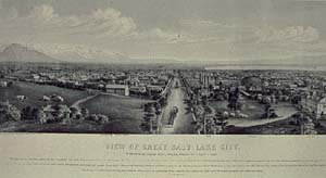 Christian Inger (active after 1857)
- View of Great Salt Lake City, 1867
- Lithograph
- 1965.168
-
- In the summer of 1847, a vanguard of Mormon pioneers led by Brigham
Young laid out the city of Great Salt Lake, as it was initially called.
The plan was essentially a checkerboard design, consisting of ten-acre
blocks with alternating frontages -- alternate blocks had houses on the
east and west sides only, while the blocks between them had houses facing
north and south. Each block consisted of eight large lots, and every house
had to be built away from the wide streets, near the center of its lot.
The temple square was a single ten-acre block, and additional blocks were
set aside for other municipal uses. This view shows the temple finished,
but it actually was not at the time. The Mormons also specified that all
streams and nearby timber lands were to be held in common.
-
-
-
-
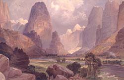 Thomas Moran (1837-1926)
- Valley of the Babbling Waters, Southern Utah, 1876
- Chromolithograph
- 1971.59.3
-
- "The scenery of southern Utah, along the Colorado River and its
branches, is the most remarkable and grand of this or any other country,"
Hayden claimed. This view shows a side gorge with the Virgin River, which
eventually empties into the Colorado. These canyons, Hayden noted, were
"stupendous examples of the carving power of water." Interestingly,
Hayden also observed that the region was so inaccessible that it must "ever
be dedicated to nature, for it can never be inhabited by man. It is unique,
grand, barren, and desolate." Of course, this was written long before
the era of off-road vehicles.
-
-
-
-
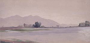 Peter Moran (1841-1914)
- Sulphur Springs, Salt Lake, c. 1879
- Watercolor, gouache, and graphite on tan paper
- 1965.70
-
- In 1879 Peter's older brother, Thomas, accepted a commission from the
Union Pacific Railroad to travel and sketch in the West. He set out with
his brother and spent much of August in Nevada and Utah, going as far as
Lake Tahoe and the Humboldt Valley. Around August 13 and 14, they were
in the vicinity of Salt Lake City, exploring Cottonwood Canyon in the Wasatch
Mountains. At the time, they complained of the dry and dusty conditions,
and the presence of numerous fires that burned unchecked. This beautiful
study of the lake and an area around a sulphur spring was undoubtedly done
during that period.
Read more articles and essays concerning this institutional
source by visiting the sub-index page for the Amon
Carter Museum in Resource Library
Magazine.
Search for more
articles and essays on American art in Resource Library. See America's Distinguished Artists for biographical information on historic artists.
This page was originally published in 2002 in Resource
Library Magazine. Please see Resource Library's Overview section for
more information.
Copyright 2012 Traditional
Fine Arts Organization, Inc., an Arizona nonprofit
corporation. All rights reserved.