Albert Tissandier: Drawings of Nature and Industry in the United States: 1885
by Mary Francey
Tissandier drawings and accompanying essays - page 2
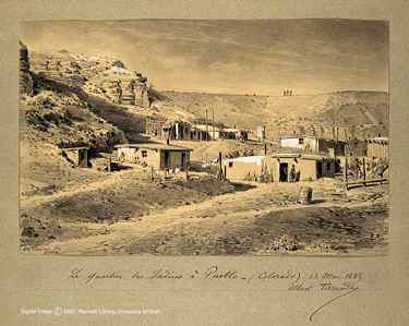
Pueblo Colorado Indian Quarters
March 13, 1885
Initially established as a trading post, Pueblo is now Colorado's second largest city. Because it was on their route, fur traders and a small number of settlers lived at the barricaded fort; the surrounding land was home to Ute Indians. Indians and white settlers did not always coexist happily. Mountain men traded furs with the Indians and some married Indian women, but relations between whites and Indians remained troubled. An Indian attack on the fort on Christmas Eve of 1854 killed everyone except one man and a few children. After this incident, Pueblo no longer attracted traders but continued its function as a settlement for travelers.
Albert Tissandier's study of these Indian quarters shows simple, one-story structures that are integrated into the bleak landscape. The square, flat-roofed houses are placed on different levels on the hillside; outside are clothes drying lines, barrels, and an outhouse tucked neatly inside a cavity in the ground. Expressing his continuing interest in Indian societies, Tissandier noted that life in the western United States was less civilized than that in the East, and neither was as civilized as in France. He wrote: "We left the territory of eastern Nebraska to enter into that of Colorado, but the landscape became more barren and abandoned. There was silence and complete isolation." This drawing clearly communicates this sense of isolation and desolation of the open prairie.
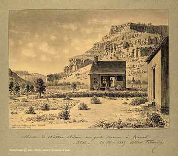
The House of Nathan Adam, My Mormon Guide at Kanab, Utah
May 28, 1885
In need of a guide for his travels through remote regions of southern Utah and northern Arizona, Albert Tissandier was directed to the town of Kanab, Utah to negotiate with Nathan Adam, a resident. On arrival he was surprised that the predominately polygamous Mormon community greeted him with distrust. Geographically isolated, southwestern Utah had become a refuge for Mormon men who, because of polygamous practices were compelled to evade federal authorities. The leaders of the Mormon church thought this remote section of Utah would be a favorable location for polygamy, a religious practice they established in 1852. National publicity how-ever aroused both public protest and government pressure for the next forty years until 1890 when a ban on new plural marriages was announced. Tissandier visited Kanab in 1885, at the same time government agents were searching households in southern Utah. The threat of prison was always present for men with multiple wives, therefore news of Tissandier's impending arrival caused mass evacuation of the town as men hid in surrounding canyons. Describing the cautious greeting he received at Nathan Adam's home, he wrote:
Nathan Adam's home is set against a backdrop of formidable canyons and rock cliffs. A figure, perhaps Adam himself, stands in the doorway of this modest but well provisioned home. The rock wall in back indicates both ownership and property division.
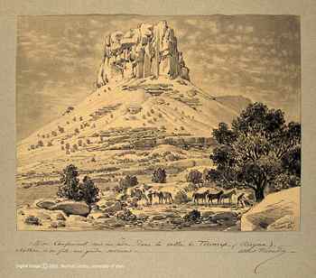
My Encampment Under the Trees In the Toroweap Valley, Arizona
with Nathan Adam and His Son, my Mormon Guides
After gathering provisions in the town of Kanab, Albert Tissandier and his party embarked on their first excursion into the canyons of Toroweap. Guided by Nathan Adam and his son, they faced unfamiliar and often dangerous terrain of the Toroweap Valley. Intrigued by the lava that was "black as the river Styx" that silhouetted sparse vegetation that managed to grow through the layer of ancient volcanic residue, Tissandier wrote: "The slag and cinders that cover the cover the ground attest to the disorder and disaster of past centuries." The volcano that had erupted centuries earlier cause craters that were covered with forests of pine trees one hundred years old and testified to past events by the weathered rock through which the trees had protruded.
Tissandier's observations about desert travel were accurate, and objective. He did not presume to offer advice to other travelers although his description of "jagged walls that extended as far as we could see and formed the horizon" is both inviting and disquieting. Another journal entry reads: "I advanced with an indefinable sense of wonder at the grandeur of this strange landscape."

Grand Canyon of the Colorado:
View of the Edge from the East in the Center of Toroweap Valley, Arizona
June 1, 1885
As they approached the precipices of Toroweap with the Colorado River below, Albert Tissandier and his party confronted "eroded gulfs 600 to 800 meters deep formed by sheer walls or gigantic tiers that descend to the river and create an unparalleled spectacle." Commenting that geologists can read the history of the entire region in the lateral walls of the crevasses, Tissandier identified the levels that represent six prehistoric periods.
The distinctive shape of the Grand Canyon was determined by the way the different rock layers have responded to erosion. Some formed slopes while others became cliffs, some eroding faster than others. "The general design" wrote Tissandier "is one of unimaginable grandeur. It is a solemn sight and one that has an extraordinary architectural quality because of the clear silhouettes and precise lines."
There was strong emerging interest in this region during the late nineteenth century because of the mineral resources, primarily copper and asbestos, found there. The first pioneer settlements along the rim developed during the 1880s soon after which residents discovered that tourism was more profitable than mining. By century's end the Grand Canyon had be-come a known tourist destination although accommodations were not much different from the mining camps from which they had developed. The Santa Fe Railroad commissioned well known artists to produce drawings, paintings, and photographs of the Canyon and assured tourists that travel to the far west was now feasible and accessible to all.
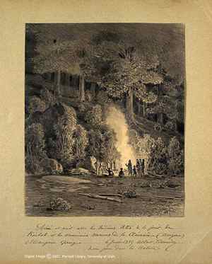
Evening Soireé with Ute Indians
in the Kaibab Forest with the American Neighbors
and Mormons from Kanab at Mangum Spring, Arizona
June 6, 1885
After a short visit to the Toroweap Plateau, Albert Tissandier, Nathan Adam and his son returned to Kanab to organize an excursion through virgin forests leading to the Kaibab Plateau. Anticipating the difficulty of traveling through the dense forest, Adam suggested they needed the assistance of an Indian guide. Adam was familiar with the Ute language and there was an Indian campsite nearby where they found John who agreed to accompany them for 6.25 francs per day for himself and his horse.
While at the campsite, Tissandier studied the "unusual dress and facial features of the Indians, He described them as:
This drawing of figures gathered around Tissandier's campsite includes the Ute Indians who were camped nearby, and two American men who lived in cabins in the same area with their wives and children, and who owned cattle and planted crops. Typically his drawing emphasizes location and scale by placing human figures within the "dark and dense foliage" of a forest thick with pine trees and nearly impenetrable underbrush.
Search Resource Library for thousands of articles and essays on American art.
Copyright 2009 Traditional Fine Arts Organization, Inc., an Arizona nonprofit corporation. All rights reserved.